IMAGES TAKEN NEAR TO
Egloshayle Road, WADEBRIDGE, PL27 6AB
Introduction
This page details the photographs taken nearby to Egloshayle Road, PL27 6AB by members of the Geograph project.
The Geograph project started in 2005 with the aim of publishing, organising and preserving representative images for every square kilometre of Great Britain, Ireland and the Isle of Man.

There are currently over 7.5m images from over14,400 individuals and you can help contribute to the project by visiting https://www.geograph.org.uk
Image Map
Images are licensed for reuse under creativecommons.org/licenses/by-sa/2.0
Notes
- Clicking on the map will re-center to the selected point.
- The higher the marker number, the further away the image location is from the centre of the postcode.
Image Listing (229 Images Found)
Images are licensed for reuse under creativecommons.org/licenses/by-sa/2.0
Image
Details
Distance
1
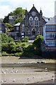
Wadebridge Methodist Chapel
The chapel is now up for sale.
Image: © Steve Daniels
Taken: 15 Jun 2011
0.05 miles
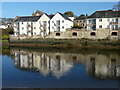
2
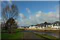
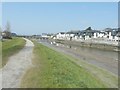
River Camel at Wadebridge
The path is mapped at 1:25000 as a cycle path, though this isn't the official Camel Trail. The river approaches the famous bridge, with houses along Egloshayle Road on the right.
Image: © Derek Harper
Taken: 31 Jan 2018
0.06 miles
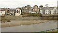
3
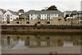
Camelside, Wadebridge
Flats on Egloshayle Road seen across the River Camel. Note the rather special riverside balconies built into the quayside.
Image: © Derek Harper
Taken: 24 Jan 2017
0.06 miles
5
Apartment block reflected in the River Camel, Wadebridge
Image: © Ruth Sharville
Taken: 28 Dec 2014
0.07 miles
6
Former warehouses on Egloshayle Road
Image: © Roger Cornfoot
Taken: 12 Aug 2016
0.08 miles
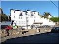
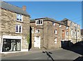
8
Buildings on Egloshayle Road, Wadebridge
Just right of centre is the former Methodist Chapel shown in Image, with the Wills Memorial Hall to the left. The chapel dates from July 1876, and the hall from 1891.
Image: © Derek Harper
Taken: 24 Jan 2017
0.09 miles
9
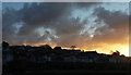
Sunrise over Wadebridge
Looking towards and beyond the bridge from a flat on Town Quay.
Image: © Derek Harper
Taken: 1 Feb 2018
0.09 miles
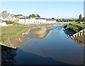
10
Low tide on the River Camel
Seen from a raised footpath beside the river. The Old Bridge is visible to the left of the row of apartments collectively called Camelside.
Image: © John Baker
Taken: 28 Mar 2013
0.09 miles