IMAGES TAKEN NEAR TO
Norman Road, PL26 8ZA
Introduction
This page details the photographs taken nearby to Norman Road, PL26 8ZA by members of the Geograph project.
The Geograph project started in 2005 with the aim of publishing, organising and preserving representative images for every square kilometre of Great Britain, Ireland and the Isle of Man.

There are currently over 7.5m images from over14,400 individuals and you can help contribute to the project by visiting https://www.geograph.org.uk
Image Map (Loading...)


Getting Data...Please wait
Leaflet Map data © OpenStreetMap
Images are licensed for reuse under creativecommons.org/licenses/by-sa/2.0
Notes
- Clicking on the map will re-center to the selected point.
- The higher the marker number, the further away the image location is from the centre of the postcode.
Image Listing (9 Images Found)
Images are licensed for reuse under creativecommons.org/licenses/by-sa/2.0
Image
Details
Distance
4
Great Carclaze China Clay Works - disused
Image: © Tony Atkin
Taken: 12 Nov 2005
0.20 miles
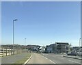
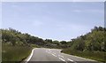
6
A391 at Carluddan Garage
Note permanent occupant of phone box
Image: © John Firth
Taken: 12 Jun 2014
0.22 miles
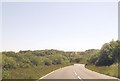
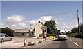
7
A391 in Carluddon
Bungalows on the right date from the 1930s
Image: © David Smith
Taken: 2 Jun 2011
0.23 miles
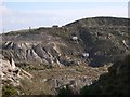
8
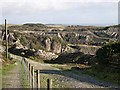
Great Carclaze China Clay Pit
A disused pit. A footpath has been built along the western side of this pit giving great views into these old workings.
Image: © Tony Atkin
Taken: 12 Nov 2005
0.24 miles
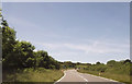
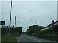
9
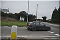
Restormel : A391 Road Junction
A road junction on the A391 near Penwithick.
Image: © Lewis Clarke
Taken: 24 Mar 2013
0.24 miles