IMAGES TAKEN NEAR TO
Penwithick Road, ST. AUSTELL, PL26 8UG
Introduction
This page details the photographs taken nearby to Penwithick Road, PL26 8UG by members of the Geograph project.
The Geograph project started in 2005 with the aim of publishing, organising and preserving representative images for every square kilometre of Great Britain, Ireland and the Isle of Man.

There are currently over 7.5m images from over14,400 individuals and you can help contribute to the project by visiting https://www.geograph.org.uk
Image Map
Images are licensed for reuse under creativecommons.org/licenses/by-sa/2.0
Notes
- Clicking on the map will re-center to the selected point.
- The higher the marker number, the further away the image location is from the centre of the postcode.
Image Listing (8 Images Found)
Images are licensed for reuse under creativecommons.org/licenses/by-sa/2.0
Image
Details
Distance
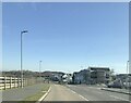
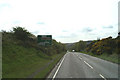
2
Restormel : A391 Road Junction
A road junction on the A391 near Penwithick.
Image: © Lewis Clarke
Taken: 24 Mar 2013
0.17 miles
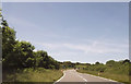
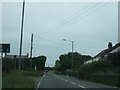
5
New course for the A391
Unrecognisable from the old OS map - a new section of road cuts out the village of Penwithick.
Image: © David Long
Taken: 9 May 2006
0.22 miles
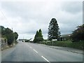
6
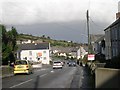
Penwithick
A village in the St Austell China Clay country.
Image: © Tony Atkin
Taken: 12 Nov 2005
0.23 miles
7
A391 in Carluddon
Bungalows on the right date from the 1930s
Image: © David Smith
Taken: 2 Jun 2011
0.24 miles
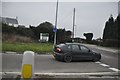
8
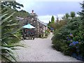
The Bothy
When we drove up and turned in to "The Bothy" we were stunned at how perfect the hideaway looked.
Image: © Gary and Barara Goss, on holiday from Essex
Taken: 15 Sep 2008
0.24 miles