IMAGES TAKEN NEAR TO
Bowling Green, Bugle, ST. AUSTELL, PL26 8RN
Introduction
This page details the photographs taken nearby to PL26 8RN by members of the Geograph project.
The Geograph project started in 2005 with the aim of publishing, organising and preserving representative images for every square kilometre of Great Britain, Ireland and the Isle of Man.

There are currently over 7.5m images from over14,400 individuals and you can help contribute to the project by visiting https://www.geograph.org.uk
Image Map
Images are licensed for reuse under creativecommons.org/licenses/by-sa/2.0
Notes
- Clicking on the map will re-center to the selected point.
- The higher the marker number, the further away the image location is from the centre of the postcode.
Image Listing (5 Images Found)
Images are licensed for reuse under creativecommons.org/licenses/by-sa/2.0
Image
Details
Distance
1
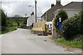
New and old signs
Looking towards Bugle .
Image: © roger geach
Taken: 1 May 2012
0.07 miles
3
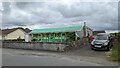
Converted Railway Carriage at Bowling Green
Image: © Sandy Gerrard
Taken: 16 Jun 2024
0.12 miles
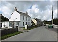
4
Bowling Green looking towards Rescorla
Sunshine and Showers on Mayday
Image: © roger geach
Taken: 1 May 2012
0.15 miles
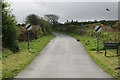
5
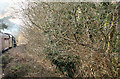
St Austell: approaching Goonbarrow Junction
At the junction is a China clay works operated by Imerys and previously by ECC. Seen from an excursion train on the Newquay branch. Looking west-north-west
Image: © Martin Bodman
Taken: 26 Mar 2007
0.22 miles