IMAGES TAKEN NEAR TO
Criggan, Bugle, ST. AUSTELL, PL26 8QX
Introduction
This page details the photographs taken nearby to PL26 8QX by members of the Geograph project.
The Geograph project started in 2005 with the aim of publishing, organising and preserving representative images for every square kilometre of Great Britain, Ireland and the Isle of Man.

There are currently over 7.5m images from over14,400 individuals and you can help contribute to the project by visiting https://www.geograph.org.uk
Image Map (4 Images)


Getting Data...Please wait
Leaflet Map data © OpenStreetMap
Images are licensed for reuse under creativecommons.org/licenses/by-sa/2.0
Notes
- Clicking on the map will re-center to the selected point.
- The higher the marker number, the further away the image location is from the centre of the postcode.
Image Listing (4 Images Found)
Images are licensed for reuse under creativecommons.org/licenses/by-sa/2.0
Image
Details
Distance
1
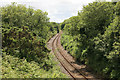
The Newquay branch from nr Criggan
View off the road overbridge looking towards Par
Image: © roger geach
Taken: 24 Jun 2012
0.17 miles
2
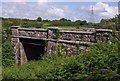
Railway bridge at Criggan
The railway out of sight in the cutting is the single-track line from Newquay to the main line at Par. The sturdy granite bridge carries the lane from Roche to the A391 at Bilberry.
Image: © Derek Harper
Taken: 22 Jun 2007
0.20 miles
3
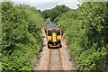
Newquay Branch train
The 1153 Par to Newquay train passing the road overbridge nr Criggan, Roche. The railway is rather overgrown here now.
Image: © roger geach
Taken: 24 Jun 2012
0.22 miles
4
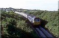
The Newquay to Par railway
The 1705 Newquay to Par service is seen in the cutting nr Criggan. This stock and loco had worked into Newquay on the 0950 ex Paddington through service.
Image: © roger geach
Taken: 9 Sep 1978
0.22 miles