IMAGES TAKEN NEAR TO
Park Lane, ST. AUSTELL, PL26 8PT
Introduction
This page details the photographs taken nearby to Park Lane, PL26 8PT by members of the Geograph project.
The Geograph project started in 2005 with the aim of publishing, organising and preserving representative images for every square kilometre of Great Britain, Ireland and the Isle of Man.

There are currently over 7.5m images from over14,400 individuals and you can help contribute to the project by visiting https://www.geograph.org.uk
Image Map
Images are licensed for reuse under creativecommons.org/licenses/by-sa/2.0
Notes
- Clicking on the map will re-center to the selected point.
- The higher the marker number, the further away the image location is from the centre of the postcode.
Image Listing (13 Images Found)
Images are licensed for reuse under creativecommons.org/licenses/by-sa/2.0
Image
Details
Distance
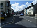
3

The Bugle Inn on Roche Road
Bugle is in the heart of the china clay country.
Image: © roger geach
Taken: 24 Jun 2012
0.03 miles

6
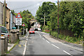
Roche Road Bugle
Looking along Roche Road Bugle in the distance is the disused china clay Stenalees railway.
Image: © roger geach
Taken: 24 Jun 2012
0.05 miles
7

Bugle : Rosevear Road
Rosevear Road in Bugle seen from the junction at Fore Street.
Image: © Lewis Clarke
Taken: 24 Mar 2013
0.05 miles