IMAGES TAKEN NEAR TO
Penstraze Lane, ST. AUSTELL, PL26 8GQ
Introduction
This page details the photographs taken nearby to Penstraze Lane, PL26 8GQ by members of the Geograph project.
The Geograph project started in 2005 with the aim of publishing, organising and preserving representative images for every square kilometre of Great Britain, Ireland and the Isle of Man.

There are currently over 7.5m images from over14,400 individuals and you can help contribute to the project by visiting https://www.geograph.org.uk
Image Map
Images are licensed for reuse under creativecommons.org/licenses/by-sa/2.0
Notes
- Clicking on the map will re-center to the selected point.
- The higher the marker number, the further away the image location is from the centre of the postcode.
Image Listing (12 Images Found)
Images are licensed for reuse under creativecommons.org/licenses/by-sa/2.0
Image
Details
Distance
1
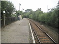
Roche railway station, Cornwall
Opened in 1876 as "Victoria" by the Cornwall Minerals Railway, later part of the Great Western Railway, on the line from Par to Newquay. The station received its current name in 1904.
View west towards St. Columb Road and Newquay. The passing loop and former platform to the right became disused from 1965 and the track removed.
Image: © Nigel Thompson
Taken: 12 Sep 2016
0.03 miles

3
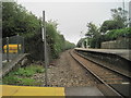
Roche railway station, Cornwall
Opened in 1876 as "Victoria" by the Cornwall Minerals Railway, later part of the Great Western Railway, on the line from Par to Newquay. The station received its current name in 1904.
View east towards Bugle and Par. The passing loop and former platform to the left became disused from 1965 and the track removed. When this image was taken, the former eastbound platform could still be seen disappearing under the undergrowth.
Image: © Nigel Thompson
Taken: 12 Sep 2016
0.03 miles
4
The railway bridge at Roche
Traffic over the bridge is controlled by traffic lights. The road is the B3274 (Victoria Road).
Image: © David Smith
Taken: 2 Jun 2011
0.07 miles
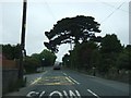
6
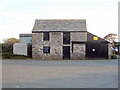
Small barn next to the car park of the Victoria Inn
A relic of the rural past of this area alongside the old A30 road, now surrounded by modern development.
Image: © Rod Allday
Taken: 27 Apr 2010
0.15 miles
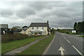
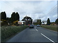
9
Times are a-changing
The garage and restaurant on the A30 will be side-lined when the new road opens to the right in 2007.
Image: © David Long
Taken: 8 May 2006
0.19 miles
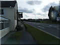
10
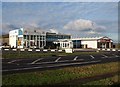
Business premises at Victoria
Home improvement outlets on the old A30, almost opposite the Victoria Inn. On the left is a conservatory salesroom, on the right a tile stockist.
Image: © Derek Harper
Taken: 17 Dec 2009
0.21 miles