IMAGES TAKEN NEAR TO
Tynance Court, ST. AUSTELL, PL26 8FL
Introduction
This page details the photographs taken nearby to Tynance Court, PL26 8FL by members of the Geograph project.
The Geograph project started in 2005 with the aim of publishing, organising and preserving representative images for every square kilometre of Great Britain, Ireland and the Isle of Man.

There are currently over 7.5m images from over14,400 individuals and you can help contribute to the project by visiting https://www.geograph.org.uk
Image Map
Images are licensed for reuse under creativecommons.org/licenses/by-sa/2.0
Notes
- Clicking on the map will re-center to the selected point.
- The higher the marker number, the further away the image location is from the centre of the postcode.
Image Listing (13 Images Found)
Images are licensed for reuse under creativecommons.org/licenses/by-sa/2.0
Image
Details
Distance

2

St Dennis Old Fire Station
St Dennis Old Fire Station, Robartes Road, St Dennis, Cornwall. Now replaced by a new fire station on Gothers Road (see Image).
Image: © Kevin Hale
Taken: 26 Sep 2004
0.07 miles
4

St Dennis
St Dennis is a large village in Cornwall's clay country. To the south and west of the village are the china clay workings on the St Austell Granite and to the north, agricultural land leading down to Goss Moor. This photograph was taken near the centre of the village and features a village shop which, according to the sign has been operating since 1850.
Image: © Tony Atkin
Taken: 17 Sep 2005
0.10 miles
5

View over the rooftops of St Dennis from St Dennis Church
Image: © Colin Park
Taken: 10 Sep 2009
0.11 miles
6

St Dennis
At the junction of Fore Street and Trelavour Road
Image: © Tony Atkin
Taken: 17 Sep 2005
0.11 miles
7
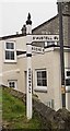
Old Direction Sign - Signpost by Trelavour Road, St Dennis
Raised finial - G; by the UC road, in parish of St Dennis (Restormel District), Trelavour Road junction with Fore Street, behind wall, lamp post and telegraph pole.
Surveyed
Milestone Society National ID: CW_SW9557.
Image: © Milestone Society
Taken: Unknown
0.12 miles