IMAGES TAKEN NEAR TO
St. Dennis, ST. AUSTELL, PL26 8BX
Introduction
This page details the photographs taken nearby to PL26 8BX by members of the Geograph project.
The Geograph project started in 2005 with the aim of publishing, organising and preserving representative images for every square kilometre of Great Britain, Ireland and the Isle of Man.

There are currently over 7.5m images from over14,400 individuals and you can help contribute to the project by visiting https://www.geograph.org.uk
Image Map (Loading...)


Getting Data...Please wait
Leaflet Map data © OpenStreetMap
Images are licensed for reuse under creativecommons.org/licenses/by-sa/2.0
Notes
- Clicking on the map will re-center to the selected point.
- The higher the marker number, the further away the image location is from the centre of the postcode.
Image Listing (23 Images Found)
Images are licensed for reuse under creativecommons.org/licenses/by-sa/2.0
Image
Details
Distance
1
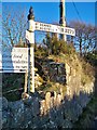
Direction Sign - Signpost on the B3279 in St Dennis parish
Pyramid spear finial - 3 arms, 2 missing; Cornwall CC iron spear by the B3279, in parish of St Dennis (Restormel District), T-junction north of St Dennis, behind a granite wall. The third and final arm was lost by 2014.
surveyed
Milestone Society National ID: CW_SW9458A
Image: © I Thompson
Taken: Unknown
0.02 miles
2
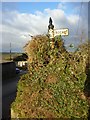
Old Direction Sign - Signpost by Carne Hill, St Dennis parish
Pyramid spear finial - 1 arm; Cornwall CC iron spear by the UC road, in parish of St Dennis (Restormel District), Carne Hill, turn for St Dennis churchtown, behind granite wall.
Cornwall & Scilly HER.
HER Number: MCO56967 https://www.heritagegateway.org.uk/Gateway/Results_Single.aspx?uid=MCO56967&resourceID=1020
Surveyed
Milestone Society National ID: CW_SW9458B
Image: © Milestone Society
Taken: Unknown
0.04 miles
3
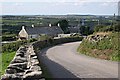
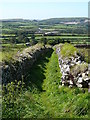
Carne Hill
Looking down to a small row of cottages and beyond to the grey tower of a major electricity sub-station at the western end of Goss Moor.
Image: © Tony Atkin
Taken: 17 Sep 2005
0.08 miles
4
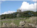
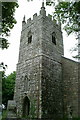
St Dennis Village Church
The church is situated on a prominent hill on the northern side of the village. This photograph was taken from the hillside to the west of the church. Only the church tower is visible through the trees which closely surround the churchyard on all sides. The church and churchyard is built inside an Iron Age fortress, the ramparts of which form the edge of the churchyard on this side of the hill. The church is dedicated to St Denys the Martyr which may have given the village of St Dennis its name. An alternative explanation is that the village derives its name from the older fortress on which the church stands. The Cornish word for fortress is 'Dynas'. I would like to think that whoever first dedicated the church chose their patron saint to closely match this Cornish word.
Image: © Tony Atkin
Taken: 17 Sep 2005
0.11 miles
5
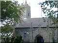
St Dennis Parish Church
The porch and tower are thought to date from the 14th century. Extensive renovations were carried out in 1847 and in the mid 1980's after a fire. The church tower has a set of 8 bells. The photographer can attest to the high quality of both bells and bellringers.
Image: © Tony Atkin
Taken: 17 Sep 2005
0.11 miles
6
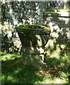
St Dennis - Church of St Dennis - External font
This font is situated outside Image] between the South Porch and the Tower. It dates from the C12th but was restored in the C19th.
It is individually Grade II listed: https://historicengland.org.uk/listing/the-list/list-entry/1138304?section=official-list-entry
Image: © Rob Farrow
Taken: 2 Sep 2023
0.14 miles
9
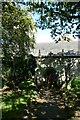
St Dennis - Path to South Porch
Looking along the path to the south porch of Image], on the right of the path, seen edge-on is Image]
Image: © Rob Farrow
Taken: 2 Sep 2023
0.14 miles
10
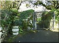
St Dennis - Gate and steps from without
The entrance to Image] from its garden to the south has two options - one can either go through the gate on the right, or if that is locked you can use the steps to its left. Cf. Image]
Beyond the gate is Image]
Image: © Rob Farrow
Taken: 2 Sep 2023
0.15 miles