IMAGES TAKEN NEAR TO
Goonavean Park, ST. AUSTELL, PL26 7UH
Introduction
This page details the photographs taken nearby to Goonavean Park, PL26 7UH by members of the Geograph project.
The Geograph project started in 2005 with the aim of publishing, organising and preserving representative images for every square kilometre of Great Britain, Ireland and the Isle of Man.

There are currently over 7.5m images from over14,400 individuals and you can help contribute to the project by visiting https://www.geograph.org.uk
Image Map
Images are licensed for reuse under creativecommons.org/licenses/by-sa/2.0
Notes
- Clicking on the map will re-center to the selected point.
- The higher the marker number, the further away the image location is from the centre of the postcode.
Image Listing (5 Images Found)
Images are licensed for reuse under creativecommons.org/licenses/by-sa/2.0
Image
Details
Distance
1
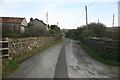
Foxhole ahead
The approach to Foxhole village from Goonabarn , the narrow road crosses the freight only railway here.
Image: © roger geach
Taken: 25 Nov 2011
0.06 miles
2
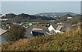
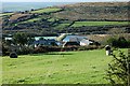
The View from Foxhole
This photograph was taken from the eastern hillside above the village of Foxhole and looks out to the northwest outside this square onto an almost totally man-made landscape of old china clay waste tips, now covered in vegetation.
Image: © Tony Atkin
Taken: 19 Nov 2005
0.10 miles
5
The Valley at Foxhole
In the valley floor are old mica settling lakes.
Image: © Tony Atkin
Taken: 19 Nov 2005
0.21 miles