IMAGES TAKEN NEAR TO
Coombe, ST. AUSTELL, PL26 7LN
Introduction
This page details the photographs taken nearby to PL26 7LN by members of the Geograph project.
The Geograph project started in 2005 with the aim of publishing, organising and preserving representative images for every square kilometre of Great Britain, Ireland and the Isle of Man.

There are currently over 7.5m images from over14,400 individuals and you can help contribute to the project by visiting https://www.geograph.org.uk
Image Map
Images are licensed for reuse under creativecommons.org/licenses/by-sa/2.0
Notes
- Clicking on the map will re-center to the selected point.
- The higher the marker number, the further away the image location is from the centre of the postcode.
Image Listing (9 Images Found)
Images are licensed for reuse under creativecommons.org/licenses/by-sa/2.0
Image
Details
Distance
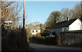
1
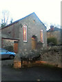
School house, Coombe
At a road junction in the village, with a blind quatrefoil over the lancet windows,
Image: © Derek Harper
Taken: 23 Jan 2017
0.06 miles
3
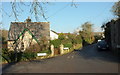
Houses at Coombe
At a junction where the lane up the valley meets Coombe Hill (right).
Image: © Derek Harper
Taken: 23 Jan 2017
0.09 miles
4
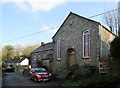
Church and post office, Coombe
Methodist church and former post office, immediately south of the junction where was taken (you can see the signpost on the left) and both listed. On the left is what was built as a house, then became the post office, and is now a house again https://www.historicengland.org.uk/listing/the-list/list-entry/1327467 . The church is "Dated 1859; enlarged 1890" https://www.historicengland.org.uk/listing/the-list/list-entry/1137015 .
Image: © Derek Harper
Taken: 23 Jan 2017
0.11 miles
5
Former Wesleyan chapel
Now Methodist Church.
Image: © Paul Barnett
Taken: 1 Jan 2017
0.11 miles
6
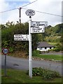
Old Direction Sign - Signpost by Coombe, St Stephen in Brannel parish
Raised finial - G type; by the UC road, in parish of St Stephen in Brannel (Restormel District), Coombe village, in Y of junction.
To be surveyed
Milestone Society National ID: CW_SW9551
Image: © Milestone Society
Taken: Unknown
0.11 miles
7
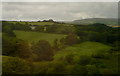
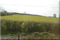
Green Lane
This view from the Resugga railway viaduct west of Coombe shows how green the area is. Lots of pastures and woodland, but with the China Clay areas of St Austell on the horizon.
This photo was taken from the 1158 Penzance to London Paddington train, having left Truro at 1244.
Image: © Graham Horn
Taken: 9 Jul 2011
0.23 miles
8
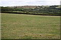
Towards Coombe
This shot looks in a southeasterly direction across the square and down the shallow valley slope.
Image: © Tony Atkin
Taken: 26 Aug 2006
0.23 miles
9
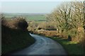
Coombe Hill
Descending from Downderry towards Coombe. Image] was taken just to the right from here.
Image: © Derek Harper
Taken: 23 Jan 2017
0.25 miles