IMAGES TAKEN NEAR TO
Hewas Water, ST. AUSTELL, PL26 7JQ
Introduction
This page details the photographs taken nearby to PL26 7JQ by members of the Geograph project.
The Geograph project started in 2005 with the aim of publishing, organising and preserving representative images for every square kilometre of Great Britain, Ireland and the Isle of Man.

There are currently over 7.5m images from over14,400 individuals and you can help contribute to the project by visiting https://www.geograph.org.uk
Image Map (Loading...)


Getting Data...Please wait
Leaflet Map data © OpenStreetMap
Images are licensed for reuse under creativecommons.org/licenses/by-sa/2.0
Notes
- Clicking on the map will re-center to the selected point.
- The higher the marker number, the further away the image location is from the centre of the postcode.
Image Listing (8 Images Found)
Images are licensed for reuse under creativecommons.org/licenses/by-sa/2.0
Image
Details
Distance
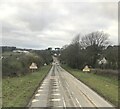
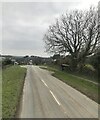
3
Road at Hewas Water
And heading for Sticker. It is followed here by the parish boundary between St Mewan (left) and Grampound with Creed.
Image: © Derek Harper
Taken: 23 Jan 2017
0.11 miles
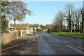
4
Building plot, Hewas Water
This area south of the road shown shown in Image] is undergoing development. On the extreme right is part of the car park for the Merlin MS Centre; the industrial building left of centre is at Hewaswater Engineering Ltd, a steel fabrication firm. the houses beyond are by the road towards London Apprentice. The building plot has been created out of a roadside belt of trees. It has planning permission for a three bedroom detached two storey property with double garage.
Image: © Derek Harper
Taken: 23 Jan 2017
0.14 miles
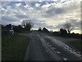
6
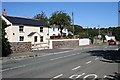
Hewas Water
Hewas Water is a hamlet to the west of Sticker. This shot was taken from the bus stop. The road through the hamlet thankfully has little traffic as the main A390 has been moved to a by-pass just north of the hamlet.
Image: © Tony Atkin
Taken: 15 Sep 2006
0.19 miles
7
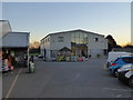
The restaurant at Griggs Country Store at Pendennis
Image: © Rod Allday
Taken: 19 Jan 2017
0.19 miles
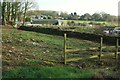
8
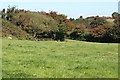
Lush Grassland
The overgrown hedgerows are red with hawthorn berries.
Image: © Tony Atkin
Taken: 15 Sep 2006
0.21 miles