IMAGES TAKEN NEAR TO
Chapel Green, ST. AUSTELL, PL26 7BQ
Introduction
This page details the photographs taken nearby to Chapel Green, PL26 7BQ by members of the Geograph project.
The Geograph project started in 2005 with the aim of publishing, organising and preserving representative images for every square kilometre of Great Britain, Ireland and the Isle of Man.

There are currently over 7.5m images from over14,400 individuals and you can help contribute to the project by visiting https://www.geograph.org.uk
Image Map (Loading...)


Getting Data...Please wait
Leaflet Map data © OpenStreetMap
Images are licensed for reuse under creativecommons.org/licenses/by-sa/2.0
Notes
- Clicking on the map will re-center to the selected point.
- The higher the marker number, the further away the image location is from the centre of the postcode.
Image Listing (8 Images Found)
Images are licensed for reuse under creativecommons.org/licenses/by-sa/2.0
Image
Details
Distance
3
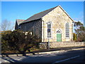
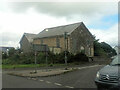
Converted chapel at Trelowth
The plaque in the gable reads 'UMFC 1872' - presumably United Methodist Free Church. It is now a private dwelling.
Image: © Rod Allday
Taken: 22 Jan 2010
0.14 miles
8
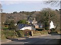
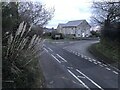
Houses at Polgooth
Polgooth is a large village stretching up the hillside from the valley bottom. Most of the village appears to be quite affluent. A favourite place to get away from it all?
Image: © Tony Atkin
Taken: 28 Jan 2006
0.25 miles