IMAGES TAKEN NEAR TO
Valley Road, ST. AUSTELL, PL26 6SA
Introduction
This page details the photographs taken nearby to Valley Road, PL26 6SA by members of the Geograph project.
The Geograph project started in 2005 with the aim of publishing, organising and preserving representative images for every square kilometre of Great Britain, Ireland and the Isle of Man.

There are currently over 7.5m images from over14,400 individuals and you can help contribute to the project by visiting https://www.geograph.org.uk
Image Map (Loading...)


Getting Data...Please wait
Leaflet Map data © OpenStreetMap
Images are licensed for reuse under creativecommons.org/licenses/by-sa/2.0
Notes
- Clicking on the map will re-center to the selected point.
- The higher the marker number, the further away the image location is from the centre of the postcode.
Image Listing (17 Images Found)
Images are licensed for reuse under creativecommons.org/licenses/by-sa/2.0
Image
Details
Distance
1
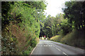
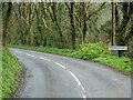
The B3273
Down the hill to Mevagissey.
Image: © Robert Ashby
Taken: 19 Aug 2014
0.10 miles
4
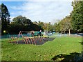
Children's playground, Valley Road, Mevagissey
Image: © David Smith
Taken: 18 Oct 2018
0.17 miles


8

Mevagissey fire station
Mevagissey fire station, Valley Road, Mevagissey, Cornwall
Image: © Kevin Hale
Taken: 8 Jul 2007
0.22 miles