IMAGES TAKEN NEAR TO
Gorran, ST. AUSTELL, PL26 6ND
Introduction
This page details the photographs taken nearby to PL26 6ND by members of the Geograph project.
The Geograph project started in 2005 with the aim of publishing, organising and preserving representative images for every square kilometre of Great Britain, Ireland and the Isle of Man.

There are currently over 7.5m images from over14,400 individuals and you can help contribute to the project by visiting https://www.geograph.org.uk
Image Map
Images are licensed for reuse under creativecommons.org/licenses/by-sa/2.0
Notes
- Clicking on the map will re-center to the selected point.
- The higher the marker number, the further away the image location is from the centre of the postcode.
Image Listing (5 Images Found)
Images are licensed for reuse under creativecommons.org/licenses/by-sa/2.0
Image
Details
Distance
4
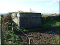
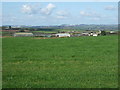
Concrete structure near Tregilgas
Not sure if this is wartime defence related or agricultural. It is fenced off from the surrounding pasture.
Image: © JThomas
Taken: 5 Nov 2014
0.15 miles
5
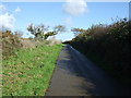
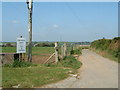
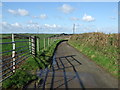
Country lane near Tregilgas
Heading north east in the general direction of Mevagissey.
Image: © JThomas
Taken: 5 Nov 2014
0.21 miles