IMAGES TAKEN NEAR TO
Duporth Bay, ST. AUSTELL, PL26 6AQ
Introduction
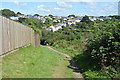
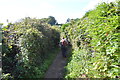
This page details the photographs taken nearby to Duporth Bay, PL26 6AQ by members of the Geograph project.
The Geograph project started in 2005 with the aim of publishing, organising and preserving representative images for every square kilometre of Great Britain, Ireland and the Isle of Man.

There are currently over 7.5m images from over14,400 individuals and you can help contribute to the project by visiting https://www.geograph.org.uk
Image Map
Images are licensed for reuse under creativecommons.org/licenses/by-sa/2.0
Notes
- Clicking on the map will re-center to the selected point.
- The higher the marker number, the further away the image location is from the centre of the postcode.
Image Listing (16 Images Found)
Images are licensed for reuse under creativecommons.org/licenses/by-sa/2.0
Image
Details
Distance
6
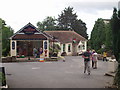
Duporth Holiday Village
near St Austell, Cornwall. This is a view of the centre of the holiday village.
Image: © G McK
Taken: 24 Jul 2003
0.12 miles
7
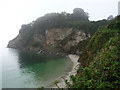
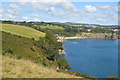
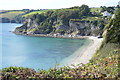
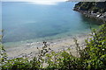
Duporth Beach and Carrickowel point
From the coast path
Image: © Chris Gunns
Taken: 22 Sep 2013
0.14 miles