IMAGES TAKEN NEAR TO
PAR, PL25 9GZ
Introduction
This page details the photographs taken nearby to PL25 9GZ by members of the Geograph project.
The Geograph project started in 2005 with the aim of publishing, organising and preserving representative images for every square kilometre of Great Britain, Ireland and the Isle of Man.

There are currently over 7.5m images from over14,400 individuals and you can help contribute to the project by visiting https://www.geograph.org.uk
Image Map
Images are licensed for reuse under creativecommons.org/licenses/by-sa/2.0
Notes
- Clicking on the map will re-center to the selected point.
- The higher the marker number, the further away the image location is from the centre of the postcode.
Image Listing (24 Images Found)
Images are licensed for reuse under creativecommons.org/licenses/by-sa/2.0
Image
Details
Distance
6
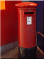
St. Austell: postbox № PL25 158, Daniels Lane
This large Elizabeth-II reign postbox (dating back to no earlier than 1994) stands outside the main entrance of the large Tesco superstore.
Image: © Chris Downer
Taken: 28 Dec 2014
0.11 miles
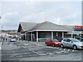
7
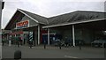
Tesco St Austell Daniels Lane Superstore
The Tesco St Austell Daniels Lane Superstore in the Holmbush area of St Austell, Cornwall.
Image: © Steven Haslington
Taken: 21 Apr 2016
0.12 miles
9
Bucklers Lane traffic lights and junction
Image: © John Firth
Taken: 12 Jun 2014
0.13 miles
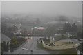
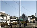
10

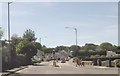
Holmbush Road
The traffic lights at the junction with Holmbush Arch Road. On the far side is a Tesco superstore.
Image: © Derek Harper
Taken: 2 Apr 2009
0.14 miles