IMAGES TAKEN NEAR TO
Fore Street, ST. AUSTELL, PL25 5PN
Introduction
This page details the photographs taken nearby to Fore Street, PL25 5PN by members of the Geograph project.
The Geograph project started in 2005 with the aim of publishing, organising and preserving representative images for every square kilometre of Great Britain, Ireland and the Isle of Man.

There are currently over 7.5m images from over14,400 individuals and you can help contribute to the project by visiting https://www.geograph.org.uk
Image Map
Images are licensed for reuse under creativecommons.org/licenses/by-sa/2.0
Notes
- Clicking on the map will re-center to the selected point.
- The higher the marker number, the further away the image location is from the centre of the postcode.
Image Listing (196 Images Found)
Images are licensed for reuse under creativecommons.org/licenses/by-sa/2.0
Image
Details
Distance
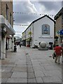
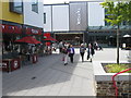
2
Fore Street in St. Austell
The pedestrianised high street.
Image: © DS Pugh
Taken: 10 Sep 2024
0.01 miles
4
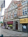
Former Liberal Club, St Austell
Dated 1890
Image: © David Smith
Taken: 17 Oct 2018
0.01 miles
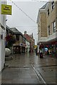
5
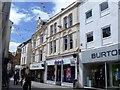
Fore Street
Two interesting buildings in Fore Street above the bland modern shopfronts.
Image: © Michael Dibb
Taken: 3 Jun 2017
0.01 miles
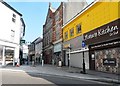
6
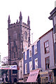
St Austell church and Fore Street
This scene was taken in August 1966. The shops have all changed ownership but the scene is otherwise the same.
Image: © mike hancock
Taken: 15 Aug 1966
0.03 miles
7
Brexitometer, St Austell
Brexitometer in the Window of the Liberal Democrats Office in St Austell
Image: © Gary Rogers
Taken: 4 Sep 2018
0.03 miles
10
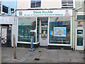
Steve Double, MP for St Austell and Newquay
Image: © Gary Rogers
Taken: 4 Sep 2018
0.05 miles