IMAGES TAKEN NEAR TO
Clover Court, PL25 5GE
Introduction
This page details the photographs taken nearby to Clover Court, PL25 5GE by members of the Geograph project.
The Geograph project started in 2005 with the aim of publishing, organising and preserving representative images for every square kilometre of Great Britain, Ireland and the Isle of Man.

There are currently over 7.5m images from over14,400 individuals and you can help contribute to the project by visiting https://www.geograph.org.uk
Image Map
Images are licensed for reuse under creativecommons.org/licenses/by-sa/2.0
Notes
- Clicking on the map will re-center to the selected point.
- The higher the marker number, the further away the image location is from the centre of the postcode.
Image Listing (10 Images Found)
Images are licensed for reuse under creativecommons.org/licenses/by-sa/2.0
Image
Details
Distance
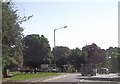
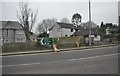
1
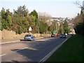
Approaching St Austell on the Truro Road
Image: © Tony Atkin
Taken: 28 Jan 2006
0.15 miles
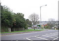
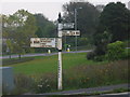
2
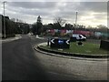
Roundabout on the A390 on the outskirts of St Austell
Image: © Paul Barnett
Taken: 6 Feb 2023
0.16 miles
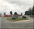
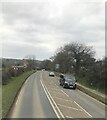
4
Truro Road (A390) on west side of St Austell
Running through western suburban St Austell
Image: © David Smith
Taken: 17 Oct 2018
0.17 miles
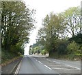
5
A390 entering St Austell at The Milestone
Image: © John Firth
Taken: 12 Jun 2014
0.22 miles
6
Junction between the A3058 and A390 west of St. Austell
Image: © nick macneill
Taken: 5 Apr 2011
0.22 miles
9
St Austell : Penwinnick Road
A sign on Penwinnick Road in St Austell.
Image: © Lewis Clarke
Taken: 24 Mar 2013
0.24 miles
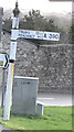
10
Old signpost at corner of Truro & Edgcumbe Roads, St Austell
Image: © John Lush
Taken: 15 Oct 2006
0.25 miles