IMAGES TAKEN NEAR TO
Priory Road, ST. AUSTELL, PL25 5FL
Introduction
This page details the photographs taken nearby to Priory Road, PL25 5FL by members of the Geograph project.
The Geograph project started in 2005 with the aim of publishing, organising and preserving representative images for every square kilometre of Great Britain, Ireland and the Isle of Man.

There are currently over 7.5m images from over14,400 individuals and you can help contribute to the project by visiting https://www.geograph.org.uk
Image Map
Images are licensed for reuse under creativecommons.org/licenses/by-sa/2.0
Notes
- Clicking on the map will re-center to the selected point.
- The higher the marker number, the further away the image location is from the centre of the postcode.
Image Listing (152 Images Found)
Images are licensed for reuse under creativecommons.org/licenses/by-sa/2.0
Image
Details
Distance

4
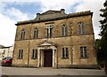
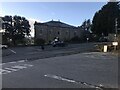
St John's Methodist Church, St Austell
As the wording over the door states, the building dates from 1828 and was restored in 1882. http://www.imagesofengland.org.uk/Details/Default.aspx?id=396369&mode=adv
Image: © Derek Harper
Taken: 18 May 2009
0.10 miles


10
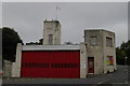
St Austell Old Fire Station
St Austell Old Fire Station, Bodmin Road (?), St Austell, Cornwall. Now replaced by a new fire station in Carlyon Road (see Image).
Image: © Kevin Hale
Taken: 26 Sep 2004
0.13 miles