IMAGES TAKEN NEAR TO
Trevanion Road, ST. AUSTELL, PL25 4SA
Introduction
This page details the photographs taken nearby to Trevanion Road, PL25 4SA by members of the Geograph project.
The Geograph project started in 2005 with the aim of publishing, organising and preserving representative images for every square kilometre of Great Britain, Ireland and the Isle of Man.

There are currently over 7.5m images from over14,400 individuals and you can help contribute to the project by visiting https://www.geograph.org.uk
Image Map
Images are licensed for reuse under creativecommons.org/licenses/by-sa/2.0
Notes
- Clicking on the map will re-center to the selected point.
- The higher the marker number, the further away the image location is from the centre of the postcode.
Image Listing (66 Images Found)
Images are licensed for reuse under creativecommons.org/licenses/by-sa/2.0
Image
Details
Distance
1
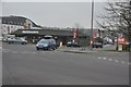
St Austell : Trevanion Road
Trevanion Road as seen through the roundabout and signs in St Austell.
Image: © Lewis Clarke
Taken: 24 Mar 2013
0.02 miles
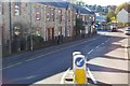
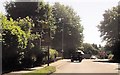
2
South Street approaching double roundabout, St Austell
Image: © JThomas
Taken: 5 Nov 2014
0.03 miles
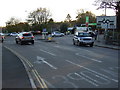
3
St Austell : Roundabouts
Roundabouts at the end of the A390 in St Austell.
Image: © Lewis Clarke
Taken: 24 Mar 2013
0.03 miles
5
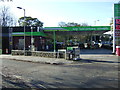
Service station on Penwinnick Road, St Austell
Image: © JThomas
Taken: 5 Nov 2014
0.05 miles
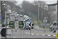
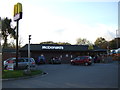
6
Approaching double roundabout by McDonald's
Image: © John Firth
Taken: 12 Jun 2014
0.06 miles

8
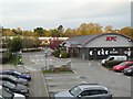
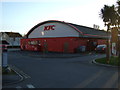
Hotel car park, KFC and B&Q, St Austell
Seen from the first floor of the Travelodge building
Image: © David Smith
Taken: 18 Oct 2018
0.06 miles