IMAGES TAKEN NEAR TO
Porthpean Road, ST. AUSTELL, PL25 4PL
Introduction
This page details the photographs taken nearby to Porthpean Road, PL25 4PL by members of the Geograph project.
The Geograph project started in 2005 with the aim of publishing, organising and preserving representative images for every square kilometre of Great Britain, Ireland and the Isle of Man.

There are currently over 7.5m images from over14,400 individuals and you can help contribute to the project by visiting https://www.geograph.org.uk
Image Map
Images are licensed for reuse under creativecommons.org/licenses/by-sa/2.0
Notes
- Clicking on the map will re-center to the selected point.
- The higher the marker number, the further away the image location is from the centre of the postcode.
Image Listing (24 Images Found)
Images are licensed for reuse under creativecommons.org/licenses/by-sa/2.0
Image
Details
Distance
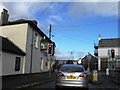
3
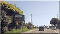
Approaching Porthpean Road crossroads
On A390 eastbound
Image: © John Firth
Taken: 12 Jun 2014
0.04 miles
4
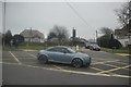
St Austell : Porthpean Road
Porthpean Road at the junction with Polmear Road.
Image: © Lewis Clarke
Taken: 24 Mar 2013
0.07 miles
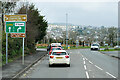
5
Cromwell Road (A390)
Heading north east towards Liskeard.
Image: © JThomas
Taken: 7 Nov 2014
0.08 miles
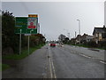
6
St Austell, Polmear Road
A390 approaching Mount Charles Roundabout.
Image: © David Dixon
Taken: 12 Apr 2022
0.09 miles
8
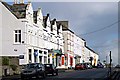
Victoria Road, Mount Charles
Terraces of three storey houses, each with a shop in the ground floor.
Image: © Tony Atkin
Taken: 12 Nov 2005
0.11 miles