IMAGES TAKEN NEAR TO
Dobell Road, ST. AUSTELL, PL25 4NB
Introduction
This page details the photographs taken nearby to Dobell Road, PL25 4NB by members of the Geograph project.
The Geograph project started in 2005 with the aim of publishing, organising and preserving representative images for every square kilometre of Great Britain, Ireland and the Isle of Man.

There are currently over 7.5m images from over14,400 individuals and you can help contribute to the project by visiting https://www.geograph.org.uk
Image Map (Loading...)


Getting Data...Please wait
Leaflet Map data © OpenStreetMap
Images are licensed for reuse under creativecommons.org/licenses/by-sa/2.0
Notes
- Clicking on the map will re-center to the selected point.
- The higher the marker number, the further away the image location is from the centre of the postcode.
Image Listing (7 Images Found)
Images are licensed for reuse under creativecommons.org/licenses/by-sa/2.0
Image
Details
Distance
1
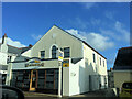
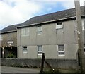
Former St Austell Downs Primitive Methodist Church
Now used as retail premises for Weathergear with a new shop front added.
Image: © Paul Barnett
Taken: 1 Jan 2019
0.08 miles
4
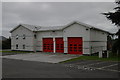
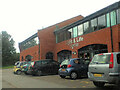
St Austell Fire Station
St Austell Fire Station, Carlyon Road, St Austell, Cornwall. Built to replace to old fire station on Bodmin Road (?) in the town centre (see Image).
Image: © Kevin Hale
Taken: 26 Sep 2004
0.18 miles
7
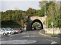
Under the Railway
The road takes a tunnel under the railway embankment in the Mount Charles district of St Austell.
Image: © Tony Atkin
Taken: 12 Nov 2005
0.24 miles