IMAGES TAKEN NEAR TO
Poltair Court, ST. AUSTELL, PL25 4JT
Introduction
This page details the photographs taken nearby to Poltair Court, PL25 4JT by members of the Geograph project.
The Geograph project started in 2005 with the aim of publishing, organising and preserving representative images for every square kilometre of Great Britain, Ireland and the Isle of Man.

There are currently over 7.5m images from over14,400 individuals and you can help contribute to the project by visiting https://www.geograph.org.uk
Image Map (Loading...)


Getting Data...Please wait
Leaflet Map data © OpenStreetMap
Images are licensed for reuse under creativecommons.org/licenses/by-sa/2.0
Notes
- Clicking on the map will re-center to the selected point.
- The higher the marker number, the further away the image location is from the centre of the postcode.
Image Listing (15 Images Found)
Images are licensed for reuse under creativecommons.org/licenses/by-sa/2.0
Image
Details
Distance
1
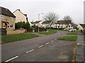
Lostwood Road, St Austell
On a housing estate in the Poltair area northeast of the town centre.
Image: © Derek Harper
Taken: 29 Jan 2009
0.10 miles
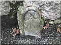
7
Tregonissey Road
Northeast of Cornwall college entrance.
Image: © P Barnett
Taken: 29 Jun 2023
0.17 miles
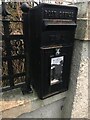
9
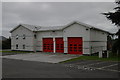
St Austell Fire Station
St Austell Fire Station, Carlyon Road, St Austell, Cornwall. Built to replace to old fire station on Bodmin Road (?) in the town centre (see Image).
Image: © Kevin Hale
Taken: 26 Sep 2004
0.19 miles
10
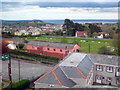
St Austell football ground
Seen from the tower of St Austell Brewery, one of the highest buildings in the town.
Image: © Rod Allday
Taken: 1 May 2010
0.20 miles