IMAGES TAKEN NEAR TO
Carnjewey Way, ST. AUSTELL, PL25 4FU
Introduction
This page details the photographs taken nearby to Carnjewey Way, PL25 4FU by members of the Geograph project.
The Geograph project started in 2005 with the aim of publishing, organising and preserving representative images for every square kilometre of Great Britain, Ireland and the Isle of Man.

There are currently over 7.5m images from over14,400 individuals and you can help contribute to the project by visiting https://www.geograph.org.uk
Image Map
Images are licensed for reuse under creativecommons.org/licenses/by-sa/2.0
Notes
- Clicking on the map will re-center to the selected point.
- The higher the marker number, the further away the image location is from the centre of the postcode.
Image Listing (13 Images Found)
Images are licensed for reuse under creativecommons.org/licenses/by-sa/2.0
Image
Details
Distance
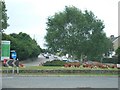
4
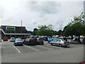
St Austell : Cromwell Road Roundabout
A roundabout on Cromwell Road with an ASDA superstore in view.
Image: © Lewis Clarke
Taken: 24 Mar 2013
0.21 miles
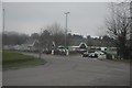
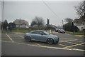
5
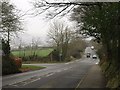
Junction on Porthpean Road
On the left is Tregorrick Road; on the right, Duporth Road, both leading to those places. The road ahead leads towards St Austell. Taken a little northwards of Image, one of the main reasons for the quantity of traffic.
Image: © Derek Harper
Taken: 29 Jan 2009
0.21 miles
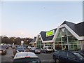
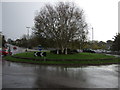
6
Roundabout on St Austell bypass
The A390 bypasses the centre of St Austell. This roundabout provides access to retail premises including Homebase.
Image: © David Smith
Taken: 2 Jun 2011
0.22 miles
8
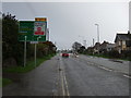
Cromwell Road (A390)
Heading north east towards Liskeard.
Image: © JThomas
Taken: 7 Nov 2014
0.23 miles
9
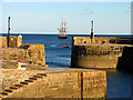
Entrance to Charlestown Harbour
Sailing ship in the bay outside the entrance to Charlestown Harbour.
Image: © Pam Brophy
Taken: 2 Aug 2006
0.23 miles
10
St Austell : Porthpean Road
Porthpean Road at the junction with Polmear Road.
Image: © Lewis Clarke
Taken: 24 Mar 2013
0.23 miles