IMAGES TAKEN NEAR TO
Boscundle Close, ST. AUSTELL, PL25 3RN
Introduction
This page details the photographs taken nearby to Boscundle Close, PL25 3RN by members of the Geograph project.
The Geograph project started in 2005 with the aim of publishing, organising and preserving representative images for every square kilometre of Great Britain, Ireland and the Isle of Man.

There are currently over 7.5m images from over14,400 individuals and you can help contribute to the project by visiting https://www.geograph.org.uk
Image Map
Images are licensed for reuse under creativecommons.org/licenses/by-sa/2.0
Notes
- Clicking on the map will re-center to the selected point.
- The higher the marker number, the further away the image location is from the centre of the postcode.
Image Listing (15 Images Found)
Images are licensed for reuse under creativecommons.org/licenses/by-sa/2.0
Image
Details
Distance
1
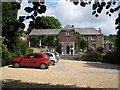
Boscundle Manor
Once home to the boss of one of Cornwall's larger and more successful mines - Wheal Eliza Consoles - Boscundle was built in the mid 18th century and is now a small hotel.
Image: © Sarah Smith
Taken: 10 Jun 2009
0.02 miles
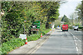
2
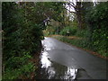
Minor road towards Tregrehan Mills
Looking north from the A390.
Image: © JThomas
Taken: 7 Nov 2014
0.03 miles
3
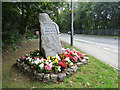
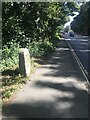
Welcome to St Blazey
An upright stone marks the start of the town coming from the west.
Image: © Stephen Craven
Taken: 6 Aug 2018
0.08 miles
4
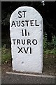
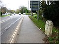
Old Milestone by the A390, near Tregrehan
Carved stone post by the A390, in parish of ST BLAISE (RESTORMEL District), Tregrehan, St Austell side of roundabout, among the modern road signs, on North side of road. St Austell Roman stone, erected by the St Austell & Lostwithiel turnpike trust in the 18th century.
Inscription reads:-
ST
AUSTEL
IIi
TRURO
XVI
Grade II Listed. List Entry Number:1379453
https://historicengland.org.uk/listing/the-list/list-entry/1379453
Milestone Society National ID: CW_TOSA16.
Image: © Ian Thompson
Taken: 10 Dec 2017
0.08 miles
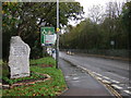
5
Old Milestone by the A390, near Tregrehan
Carved stone post by the A390, in parish of ST BLAISE (RESTORMEL District), Tregrehan, St Austell side of roundabout, among the modern road signs, on North side of road. St Austell Roman stone, erected by the St Austell & Lostwithiel turnpike trust in the 18th century.
Inscription reads:-
ST
AUSTEL
IIi
TRURO
XVI
Grade II listed.
List Entry Number: 1379453 https://historicengland.org.uk/listing/the-list/list-entry/1379453
Milestone Society National ID: CW_TOSA16.
Image: © Rosy Hanns
Taken: 7 Apr 2019
0.08 miles
6
Old Milestone by the A390, near Tregrehan
Carved stone post by the A390, in parish of St Blaise (Restormel District), Tregrehan, St Austell side of roundabout, among the modern road signs, on North side of road. St Austell Roman stone, erected by the St Austell & Lostwithiel turnpike trust in the 18th century.
Inscription reads:-
ST
AUSTEL
IIi
TRURO
XVI
Grade II listed.
List Entry Number: 1379453 https://historicengland.org.uk/listing/the-list/list-entry/1379453
Milestone Society National ID: CW_TOSA16
Image: © Paul Barnett
Taken: 6 Sep 2023
0.08 miles
9
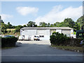
Edge-Edge plumbing, Tregrehan Mills
Housed in a modern industrial building.
Image: © Stephen Craven
Taken: 6 Aug 2018
0.15 miles
10
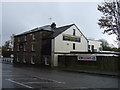
The Britannia Inn
On St Austell Road (A390).
Image: © JThomas
Taken: 7 Nov 2014
0.20 miles