IMAGES TAKEN NEAR TO
Trenowah Road, ST. AUSTELL, PL25 3FU
Introduction
This page details the photographs taken nearby to Trenowah Road, PL25 3FU by members of the Geograph project.
The Geograph project started in 2005 with the aim of publishing, organising and preserving representative images for every square kilometre of Great Britain, Ireland and the Isle of Man.

There are currently over 7.5m images from over14,400 individuals and you can help contribute to the project by visiting https://www.geograph.org.uk
Image Map
Images are licensed for reuse under creativecommons.org/licenses/by-sa/2.0
Notes
- Clicking on the map will re-center to the selected point.
- The higher the marker number, the further away the image location is from the centre of the postcode.
Image Listing (19 Images Found)
Images are licensed for reuse under creativecommons.org/licenses/by-sa/2.0
Image
Details
Distance
1
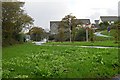
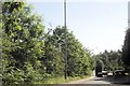
Housing on the edge of St Austell
This photo was taken from just in front of a roundabout on the ring road.
Image: © Tony Atkin
Taken: 12 Nov 2005
0.15 miles
4
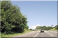
Holmbush Road (A390)
Heading north east towards Liskeard.
Image: © JThomas
Taken: 7 Nov 2014
0.17 miles
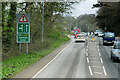
5
The A390/A391 junction at Bethel
This is the view north up the A391 to Bugle and Bodmin from the A390 close to St Austell.
Image: © Nigel Mykura
Taken: 29 Feb 2016
0.17 miles
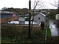
6
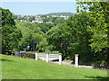
Entrance to Pine Lodge Gardens from the car park
Image: © Chris Allen
Taken: 25 May 2017
0.18 miles
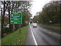
7
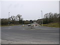
First roundabout on A391 north of A390 junction
Image: © John Firth
Taken: 12 Jun 2014
0.19 miles
8
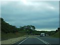
Yet another roundabout on the A391 hill
The final roundabout on the descent from Carluddon to the A390. This roundabout is preceded by an escape lane.
Image: © David Smith
Taken: 2 Jun 2011
0.20 miles
10
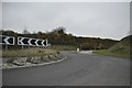
St Austell : A391 Roundabout
A roundabout outside of St Austell on the A391.
Image: © Lewis Clarke
Taken: 24 Mar 2013
0.20 miles