IMAGES TAKEN NEAR TO
Bucklers Lane, ST. AUSTELL, PL25 3FP
Introduction
This page details the photographs taken nearby to Bucklers Lane, PL25 3FP by members of the Geograph project.
The Geograph project started in 2005 with the aim of publishing, organising and preserving representative images for every square kilometre of Great Britain, Ireland and the Isle of Man.

There are currently over 7.5m images from over14,400 individuals and you can help contribute to the project by visiting https://www.geograph.org.uk
Image Map
Images are licensed for reuse under creativecommons.org/licenses/by-sa/2.0
Notes
- Clicking on the map will re-center to the selected point.
- The higher the marker number, the further away the image location is from the centre of the postcode.
Image Listing (25 Images Found)
Images are licensed for reuse under creativecommons.org/licenses/by-sa/2.0
Image
Details
Distance
1
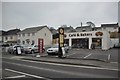
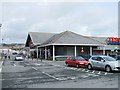
St Austell : Nile's Bakery
Nile's Bakery on Holmbush Road in St Austell.
Image: © Lewis Clarke
Taken: 24 Mar 2013
0.05 miles
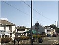
3
Bucklers Lane traffic lights and junction
Image: © John Firth
Taken: 12 Jun 2014
0.08 miles
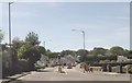
10
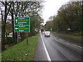
Holmbush Road (A390)
Heading north east towards Liskeard.
Image: © JThomas
Taken: 7 Nov 2014
0.16 miles