IMAGES TAKEN NEAR TO
Middleway, PAR, PL24 2LB

Introduction

This page details the photographs taken nearby to Middleway, PL24 2LB by members of the Geograph project.

The Geograph project started in 2005 with the aim of publishing, organising and preserving representative images for every square kilometre of Great Britain, Ireland and the Isle of Man.

There are currently over 7.5m images from over14,400 individuals and you can help contribute to the project by visiting https://www.geograph.org.uk

Image Map


Images are licensed for reuse under creativecommons.org/licenses/by-sa/2.0
Notes
  • Clicking on the map will re-center to the selected point.
  • The higher the marker number, the further away the image location is from the centre of the postcode.

Image Listing (4 Images Found)

Images are licensed for reuse under creativecommons.org/licenses/by-sa/2.0
Image
Details
Distance
1
Rose Hill, St Blazey
St Blazey (Cornish: Lanndreth) is a small town in Cornwall, 3 miles (4.8 km) east of St Austell. The town takes its name from the Armenian Saint Blaise who, in Christian tradition, is believed to have "cure[d] toothache, sore throats and cattle diseases". The local mining industries once dominated the town; historically copper and tin were mined in and around the parish, whilst more recently china clay has been the principal commodity mined. Image is located about a mile and a half (2 km) from the centre of the town and the large number of visitors this attracts has led to the development of tourism in the town. St Blazey. (2022, April 23). In Wikipedia. https://en.wikipedia.org/wiki/St_Blazey
Image: © David Dixon Taken: 12 Apr 2022
0.08 miles
2
Bus Stop near Doubletrees School
Image: © David Dixon Taken: 12 Apr 2022
0.10 miles
3
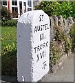
Old Milestone by the A390, Doubletrees, St Blazey Gate
Carved stone post by the A390, in parish of ST BLAISE (RESTORMEL District), Doubletrees, St Blazey Gate, by Milestone Cottage, in the garden wall, on North side of road. St Austell Roman stone, erected by the St Austell & Lostwithiel turnpike trust in the 18th century. Inscription reads:- Sᵀ. AUSTEL IIIi TRURO XVII Carved benchmark on front face. Grade II listed. List Entry Number: 1395485 https://historicengland.org.uk/listing/the-list/list-entry/1395485 Milestone Society National ID: CW_TOSA17.
Image: © Ian Thompson Taken: Unknown
0.21 miles
4
Old Milestone by the A390, St Blazey Gate
Carved stone post by the A390, in parish of ST BLAISE (RESTORMEL District), Doubletrees, St Blazey Gate, by Milestone Cottage, in the garden wall, on North side of road. St Austell Roman stone, erected by the St Austell & Lostwithiel turnpike trust in the 18th century. Inscription reads:- Sᵀ. AUSTEL IIIi TRURO XVII Carved benchmark on lower front face. Grade II listed. List Entry Number: 1395485 https://historicengland.org.uk/listing/the-list/list-entry/1395485 Milestone Society National ID: CW_TOSA17.
Image: © Rosy Hanns Taken: 7 Apr 2019
0.21 miles