IMAGES TAKEN NEAR TO
Par Harbour, PAR, PL24 2BN
Introduction
This page details the photographs taken nearby to Par Harbour, PL24 2BN by members of the Geograph project.
The Geograph project started in 2005 with the aim of publishing, organising and preserving representative images for every square kilometre of Great Britain, Ireland and the Isle of Man.

There are currently over 7.5m images from over14,400 individuals and you can help contribute to the project by visiting https://www.geograph.org.uk
Image Map (Loading...)


Getting Data...Please wait
Leaflet Map data © OpenStreetMap
Images are licensed for reuse under creativecommons.org/licenses/by-sa/2.0
Notes
- Clicking on the map will re-center to the selected point.
- The higher the marker number, the further away the image location is from the centre of the postcode.
Image Listing (59 Images Found)
Images are licensed for reuse under creativecommons.org/licenses/by-sa/2.0
Image
Details
Distance

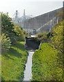
6
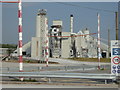
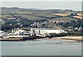
Imerys china clay milling and drying plant
This is the new plant at Par Docks that has replaced the now derelict plant that used to blast columns of steam skywards 24/7. This is a centralised plant for the Imerys china clay operation. Export by sea is from Fowey as Par closed to the trade some years back.
Image: © Chris Allen
Taken: 23 May 2018
0.09 miles