IMAGES TAKEN NEAR TO
Montpelier Road, PLYMOUTH, PL2 3LP
Introduction
This page details the photographs taken nearby to Montpelier Road, PL2 3LP by members of the Geograph project.
The Geograph project started in 2005 with the aim of publishing, organising and preserving representative images for every square kilometre of Great Britain, Ireland and the Isle of Man.

There are currently over 7.5m images from over14,400 individuals and you can help contribute to the project by visiting https://www.geograph.org.uk
Image Map
Images are licensed for reuse under creativecommons.org/licenses/by-sa/2.0
Notes
- Clicking on the map will re-center to the selected point.
- The higher the marker number, the further away the image location is from the centre of the postcode.
Image Listing (54 Images Found)
Images are licensed for reuse under creativecommons.org/licenses/by-sa/2.0
Image
Details
Distance
1
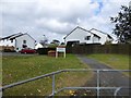
Footpath into St Boniface Park
The sign warns that this is a private estate
Image: © David Smith
Taken: 26 Sep 2014
0.13 miles
3

Lodge and drive of Pound's House - Plymouth
Image: © Mick Lobb
Taken: 1 Feb 2010
0.14 miles
5

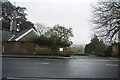
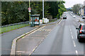
Outland's Road - Plymouth
Now one of the main arteries to and from the city.
Image: © Mick Lobb
Taken: 1 Feb 2010
0.15 miles
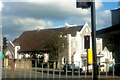
6
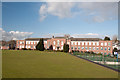
Devonport High School for Girls - Plymouth
No longer a mere 'grammar school' but now a 'specialist language school'.
Image: © Mick Lobb
Taken: 1 Feb 2010
0.15 miles
8
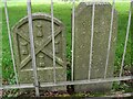
Old Boundary Markers on Outland Road, Plymouth
Two Municipal Boundary Markers inside the railings of Peverell Park on the southeast side of the A386 Outland Road, Plymouth, opposite Meredith Road.
On the left is DV_PCBS68pb, inscribed JOHN PETHICK / 1900. A boundary revision took place in 1898 when Plymouth Borough acquired some additional territory to the north of the town from Pennycross. This took the northern boundary up to what is now Outland Road opposite the present Devonport High School for Girls.
On the right is DV_PLTV08Bpb, BOROUGH / OF / DEVONPORT / 1898 / W. HORNBROOK / MAYOR. The Devonport Extension Act 1898 added parts of St Budeaux parish to Devonport.
Image: © T Jenkinson
Taken: 21 Sep 2011
0.15 miles
10
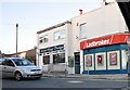
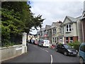
Plymouth : Beauchamp Road
Shops on Beauchamp Road seen here are Ladbrokes and Atlas Hair Design. This photo was taken from outland Road.
Image: © Lewis Clarke
Taken: 19 Jan 2011
0.16 miles