IMAGES TAKEN NEAR TO
Greatlands Crescent, PLYMOUTH, PL2 3JE
Introduction
This page details the photographs taken nearby to Greatlands Crescent, PL2 3JE by members of the Geograph project.
The Geograph project started in 2005 with the aim of publishing, organising and preserving representative images for every square kilometre of Great Britain, Ireland and the Isle of Man.

There are currently over 7.5m images from over14,400 individuals and you can help contribute to the project by visiting https://www.geograph.org.uk
Image Map (Loading...)


Getting Data...Please wait
Leaflet Map data © OpenStreetMap
Images are licensed for reuse under creativecommons.org/licenses/by-sa/2.0
Notes
- Clicking on the map will re-center to the selected point.
- The higher the marker number, the further away the image location is from the centre of the postcode.
Image Listing (58 Images Found)
Images are licensed for reuse under creativecommons.org/licenses/by-sa/2.0
Image
Details
Distance
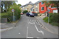
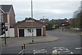
2
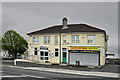
North Prospect Council Office and chinese restaurant - Plymouth
Image: © Mick Lobb
Taken: 1 May 2010
0.10 miles
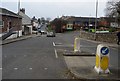
3
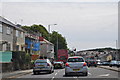
Plymouth : Wolseley Road, A3064
Heading along Wolseley Road and into Plymouth.
Image: © Lewis Clarke
Taken: 17 Jul 2015
0.11 miles
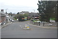
9
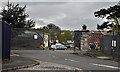
Gateway to Scott Business Park, North Prospect - Plymouth
Dating from the late 19th century the site previously contained the Devonport Borough Isolation Hospital, renamed the Scott Isolation Hospital in memory of Captain Robert Falcon Scott the explorer in 1955. The hospital grew from one catering for 24 patients suffering diseases such as Smallpox and Scarlet Fever to one meeting the needs of 170 patients.
With advances in medicine and the new Derriford Hospital catering for most medical needs of the local population it had ceased to function as a hospital by the late 1980's. A Child Development Centre was opened in 1991 and the site has developed to hold a business park as well as other organisations of a welfare nature such as a Healthy Living Centre and Plymouth Heartbeat, charity providing cardiac health support, as well as light engineering works and office facilities.
Image: © Mick Lobb
Taken: 1 May 2010
0.12 miles