IMAGES TAKEN NEAR TO
Fisher Road, PLYMOUTH, PL2 3BB
Introduction
This page details the photographs taken nearby to Fisher Road, PL2 3BB by members of the Geograph project.
The Geograph project started in 2005 with the aim of publishing, organising and preserving representative images for every square kilometre of Great Britain, Ireland and the Isle of Man.

There are currently over 7.5m images from over14,400 individuals and you can help contribute to the project by visiting https://www.geograph.org.uk
Image Map (Loading...)


Getting Data...Please wait
Leaflet Map data © OpenStreetMap
Images are licensed for reuse under creativecommons.org/licenses/by-sa/2.0
Notes
- Clicking on the map will re-center to the selected point.
- The higher the marker number, the further away the image location is from the centre of the postcode.
Image Listing (81 Images Found)
Images are licensed for reuse under creativecommons.org/licenses/by-sa/2.0
Image
Details
Distance
1
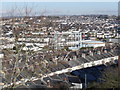
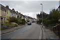
The rooftops of Ford, Plymouth
Viewed from Mount Pleasant.
Image: © Roger Cornfoot
Taken: 2 Jan 2010
0.06 miles
2
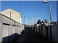
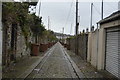
Back alley, Ford
This cobbled alley runs between housing on Ford Hill (left) and Ganges Road (right). Nice and wide to allow the refuse van access.
Image: © Derek Harper
Taken: 9 Feb 2010
0.07 miles
3
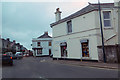
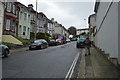
Road junction
Junction of Molesworth Street and Devonport Road.
Image: © Robert Ashby
Taken: 22 Apr 2014
0.09 miles