IMAGES TAKEN NEAR TO
Gallants Drive, FOWEY, PL23 1JE
Introduction
This page details the photographs taken nearby to Gallants Drive, PL23 1JE by members of the Geograph project.
The Geograph project started in 2005 with the aim of publishing, organising and preserving representative images for every square kilometre of Great Britain, Ireland and the Isle of Man.

There are currently over 7.5m images from over14,400 individuals and you can help contribute to the project by visiting https://www.geograph.org.uk
Image Map (Loading...)


Getting Data...Please wait
Leaflet Map data © OpenStreetMap
Images are licensed for reuse under creativecommons.org/licenses/by-sa/2.0
Notes
- Clicking on the map will re-center to the selected point.
- The higher the marker number, the further away the image location is from the centre of the postcode.
Image Listing (113 Images Found)
Images are licensed for reuse under creativecommons.org/licenses/by-sa/2.0
Image
Details
Distance
1
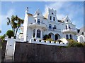
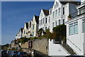
A house called Trezunger
A magnificent house on the road out of Fowey. It bears the name Trezunger.
Image: © Len Williams
Taken: 28 Jun 2012
0.04 miles
2
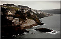
Fowey from St Catherine?s Castle
Fowey (Cornish: Fowydh, meaning 'beech trees) is a small town, civil parish and cargo port at the mouth of the River Fowey. The town has been in existence since well before the Norman invasion, with the local church first established some time in the 7th century; the estuary of the River Fowey forms a natural harbour which enabled the town to become an important trading centre. Privateers also made use of the sheltered harbourage. The Lostwithiel and Fowey Railway brought China clay here for export https://en.wikipedia.org/wiki/Fowey
Image: © John Baker
Taken: 25 Mar 1985
0.04 miles
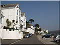
4
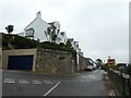
Tower Park, Fowey
The road takes its name from the ornate tower on the left. The coast path follows this road.
Image: © David Smith
Taken: 16 Oct 2018
0.05 miles
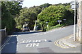
6
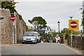
Esplanade Road, Fowey
Taken at the junction that links the road with Tower Park, and Readymoney Road.
Image: © Oliver Mills
Taken: 15 Jul 2015
0.05 miles
7
Esplanade, Fowey
This is roughly the point at which Tower Park becomes The Esplanade. On the left is St Catherine's Court, now converted into 10 apartments.
Image: © Derek Harper
Taken: 2 Apr 2009
0.05 miles
9
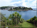
Palm trees at Readymoney
With Polruan visible across the estuary.
Image: © John Lucas
Taken: 8 Aug 2017
0.07 miles
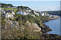
10
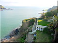
View Towards St Catherines Point
In the foreground is one of the many gardens clinging to the cliffs above the harbour in the estuary of the River Fowey. St Catherine's Point is in the distance on the right.
Image: © Nigel Mykura
Taken: 28 Feb 2016
0.08 miles