IMAGES TAKEN NEAR TO
Walmsley Lane, FOWEY, PL23 1EX
Introduction
This page details the photographs taken nearby to Walmsley Lane, PL23 1EX by members of the Geograph project.
The Geograph project started in 2005 with the aim of publishing, organising and preserving representative images for every square kilometre of Great Britain, Ireland and the Isle of Man.

There are currently over 7.5m images from over14,400 individuals and you can help contribute to the project by visiting https://www.geograph.org.uk
Image Map
Images are licensed for reuse under creativecommons.org/licenses/by-sa/2.0
Notes
- Clicking on the map will re-center to the selected point.
- The higher the marker number, the further away the image location is from the centre of the postcode.
Image Listing (16 Images Found)
Images are licensed for reuse under creativecommons.org/licenses/by-sa/2.0
Image
Details
Distance
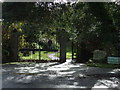
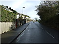
1
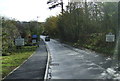
Polvillion Road (B3415)
Heading east into Fowey.
Image: © JThomas
Taken: 7 Nov 2014
0.14 miles
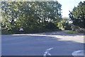
3
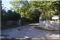
Footpath off Polvillion Road
Towards Readymoney.
Image: © JThomas
Taken: 7 Nov 2014
0.16 miles
4
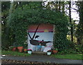
Luxurious bus shelter on Polvillion Road, Fowey
Complete with chairs.
Image: © JThomas
Taken: 7 Nov 2014
0.17 miles
7
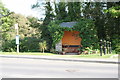
Bus shelter at the junction of Lankelly Lane and the B3415 in Fowey
Every home comfort!
Image: © Rod Allday
Taken: 12 May 2008
0.17 miles
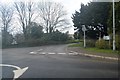
8
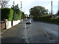
Polvillion Road (B3415), Fowey
Heading east.
Image: © JThomas
Taken: 7 Nov 2014
0.19 miles