IMAGES TAKEN NEAR TO
Kirkstall Close, PLYMOUTH, PL2 2SD
Introduction
This page details the photographs taken nearby to Kirkstall Close, PL2 2SD by members of the Geograph project.
The Geograph project started in 2005 with the aim of publishing, organising and preserving representative images for every square kilometre of Great Britain, Ireland and the Isle of Man.

There are currently over 7.5m images from over14,400 individuals and you can help contribute to the project by visiting https://www.geograph.org.uk
Image Map
Images are licensed for reuse under creativecommons.org/licenses/by-sa/2.0
Notes
- Clicking on the map will re-center to the selected point.
- The higher the marker number, the further away the image location is from the centre of the postcode.
Image Listing (11 Images Found)
Images are licensed for reuse under creativecommons.org/licenses/by-sa/2.0
Image
Details
Distance
2
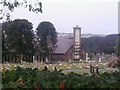
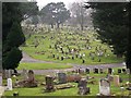
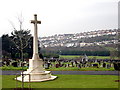
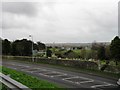
Weston Mill crematorium
Weston Mill Crematorium, Plymouth
Image: © timothy luckham
Taken: 21 Aug 2013
0.15 miles
3
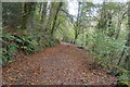
A quiet road
A quiet treelined road in Ham.
Image: © Robert Ashby
Taken: 22 Apr 2014
0.17 miles
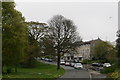
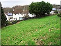
6
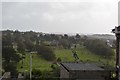
Weston Mill Cemetery
Looking over to the houses on the north side of Weston Mill valley.
Image: © Tony Atkin
Taken: 7 Jan 2006
0.19 miles
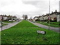
8

Ham Green Shops
Seen through the trees, this is one of the planned local shopping centres built as part of the post-war redevelopment of Plymouth.
Image: © Tony Atkin
Taken: 7 Jan 2006
0.22 miles
9
Former allotment gardens planted with apple trees
Image: © Alex McGregor
Taken: 7 Jan 2015
0.23 miles