IMAGES TAKEN NEAR TO
Vixen Way, PLYMOUTH, PL2 2QW
Introduction
This page details the photographs taken nearby to Vixen Way, PL2 2QW by members of the Geograph project.
The Geograph project started in 2005 with the aim of publishing, organising and preserving representative images for every square kilometre of Great Britain, Ireland and the Isle of Man.

There are currently over 7.5m images from over14,400 individuals and you can help contribute to the project by visiting https://www.geograph.org.uk
Image Map (Loading...)


Getting Data...Please wait
Leaflet Map data © OpenStreetMap
Images are licensed for reuse under creativecommons.org/licenses/by-sa/2.0
Notes
- Clicking on the map will re-center to the selected point.
- The higher the marker number, the further away the image location is from the centre of the postcode.
Image Listing (18 Images Found)
Images are licensed for reuse under creativecommons.org/licenses/by-sa/2.0
Image
Details
Distance
1
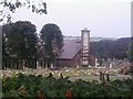
Weston Mill crematorium
Weston Mill Crematorium, Plymouth
Image: © timothy luckham
Taken: 21 Aug 2013
0.15 miles
2
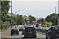
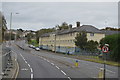
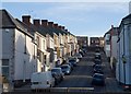
Plymouth : Wolseley Road, A3064
A road heading through the city of Plymouth.
Image: © Lewis Clarke
Taken: 17 Jul 2015
0.20 miles
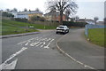
9
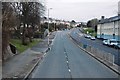
Erith Avenue, Camel's Head
Looking across Wolseley Road. Since the two parallel streets, both cul-de-sacs which climbs the hill to the west, are Second Avenue and Third Avenue, one might have expected this to be First Avenue.
Image: © Derek Harper
Taken: 9 Feb 2010
0.22 miles
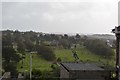
10
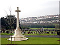
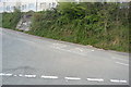
Weston Mill Cemetery
Looking over to the houses on the north side of Weston Mill valley.
Image: © Tony Atkin
Taken: 7 Jan 2006
0.23 miles