IMAGES TAKEN NEAR TO
Lowerside, PLYMOUTH, PL2 2HU
Introduction
This page details the photographs taken nearby to Lowerside, PL2 2HU by members of the Geograph project.
The Geograph project started in 2005 with the aim of publishing, organising and preserving representative images for every square kilometre of Great Britain, Ireland and the Isle of Man.

There are currently over 7.5m images from over14,400 individuals and you can help contribute to the project by visiting https://www.geograph.org.uk
Image Map (30 Images)


Getting Data...Please wait
Leaflet Map data © OpenStreetMap
Images are licensed for reuse under creativecommons.org/licenses/by-sa/2.0
Notes
- Clicking on the map will re-center to the selected point.
- The higher the marker number, the further away the image location is from the centre of the postcode.
Image Listing (30 Images Found)
Images are licensed for reuse under creativecommons.org/licenses/by-sa/2.0
Image
Details
Distance
1
Former allotment gardens planted with apple trees
Image: © Alex McGregor
Taken: 7 Jan 2015
0.02 miles
3
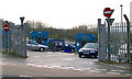
Weston Mill Recycling Centre
This is just an enclosure with some industrial skips to throw the rubbish in. It is a convenience for the people of western Plymouth. Waste collected here is taken to the main recycling centre at Chelston Meadows for processing.
Image: © Tony Atkin
Taken: 7 Jan 2006
0.07 miles