IMAGES TAKEN NEAR TO
Scrations Lane, LOSTWITHIEL, PL22 0SL
Introduction
This page details the photographs taken nearby to Scrations Lane, PL22 0SL by members of the Geograph project.
The Geograph project started in 2005 with the aim of publishing, organising and preserving representative images for every square kilometre of Great Britain, Ireland and the Isle of Man.

There are currently over 7.5m images from over14,400 individuals and you can help contribute to the project by visiting https://www.geograph.org.uk
Image Map (Loading...)


Getting Data...Please wait
Leaflet Map data © OpenStreetMap
Images are licensed for reuse under creativecommons.org/licenses/by-sa/2.0
Notes
- Clicking on the map will re-center to the selected point.
- The higher the marker number, the further away the image location is from the centre of the postcode.
Image Listing (54 Images Found)
Images are licensed for reuse under creativecommons.org/licenses/by-sa/2.0
Image
Details
Distance
2
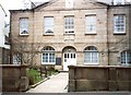
The Old Grammar School, Queen Street, Lostwithiel
This building of 1781 is now only a façade, as in 1981 the building behind was demolished and a block of six apartments built in its place. Apart from being a school, it also served as a market hall and assembly rooms.
Image: © Humphrey Bolton
Taken: 7 Mar 2001
0.10 miles
5
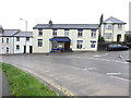
Restormel Lodge, Castle Hill
A Best Western 3 star AA hotel with outdoor heated swimming pool and 36 rooms offering modern comfort and traditional hospitality.
Image: © Peter Holmes
Taken: 8 May 2014
0.14 miles
6
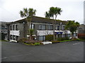
Restormel Lodge Hotel, Lostwithiel
Viewed from the rear car park; the palm-like trees are Cordyline australis.
Image: © Jonathan Billinger
Taken: 18 Dec 2008
0.16 miles
8
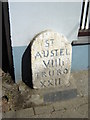
Old Milepost A390
I have no way of dating the stone but two things of note, is the mileage to St Austell eight and a half miles in Roman Numerals and was the old spelling of St Austell with one L or did the Stonemason run out of stone!
Image: © Martin Dawes
Taken: 16 Jun 2009
0.16 miles
9
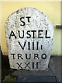
Old Milestone by the A390 in Lostwithiel
Carved stone post by the A390, in parish of LOSTWITHIEL (RESTORMEL District), Queen Street, opposite junction with B3268, in pavement against wall of shop ("Interior"). Blue writing, on South side of road. St Austell Roman stone, erected by the St Austell & Lostwithiel turnpike trust in the 18th century.
Inscription reads:-
Sᵀ
AUSTEL
VIIIi
TRURO
XXII
Grade II listed.
List Entry Number: 1144244 https://historicengland.org.uk/listing/the-list/list-entry/1144244
Milestone Society National ID: CW_TOSA22.
Image: © Rosy Hanns
Taken: 5 Apr 2019
0.16 miles
10
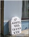
Old Milestone by the A390 in Lostwithiel
Carved stone post by the A390, in parish of LOSTWITHIEL (RESTORMEL District), Queen Street, opposite junction with B3268, in pavement against wall of shop ("Interior"). Blue writing, on South side of road. St Austell Roman stone, erected by the St Austell & Lostwithiel turnpike trust in the 18th century.
Inscription reads:-
ST
AUSTEL
VIIIi
TRURO
XXII
Grade II Listed. List Entry Number:1144244
https://historicengland.org.uk/listing/the-list/list-entry/1144244
Milestone Society National ID: CW_TOSA22.
Image: © Ian Thompson
Taken: 1 Jan 2006
0.16 miles