IMAGES TAKEN NEAR TO
LOSTWITHIEL, PL22 0NF
Introduction
This page details the photographs taken nearby to PL22 0NF by members of the Geograph project.
The Geograph project started in 2005 with the aim of publishing, organising and preserving representative images for every square kilometre of Great Britain, Ireland and the Isle of Man.

There are currently over 7.5m images from over14,400 individuals and you can help contribute to the project by visiting https://www.geograph.org.uk
Image Map (Loading...)


Getting Data...Please wait
Leaflet Map data © OpenStreetMap
Images are licensed for reuse under creativecommons.org/licenses/by-sa/2.0
Notes
- Clicking on the map will re-center to the selected point.
- The higher the marker number, the further away the image location is from the centre of the postcode.
Image Listing (4 Images Found)
Images are licensed for reuse under creativecommons.org/licenses/by-sa/2.0
Image
Details
Distance
1
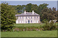
Ethy, Lerryn
Georgian, "rendered with freestone and granite dressings" according to the listing. The facade is divided into 2-3-2 bays by giant pilasters. Grade II* listed.
Image: © Stephen Richards
Taken: 17 May 2004
0.05 miles
2
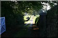
Private drive to Ethy
Private drive off the Lostwithiel to Lerryn road just before the hill gets steep down into Lerryn village.
Image: © roger geach
Taken: 8 Oct 2009
0.21 miles
4
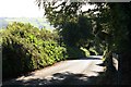
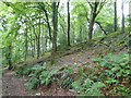
Down the hill towards Lerryn village
Looking down the hill this is the road from Lostwithiel which is narrow and steep in places.
Image: © roger geach
Taken: 8 Oct 2009
0.23 miles