IMAGES TAKEN NEAR TO
LOSTWITHIEL, PL22 0LG
Introduction
This page details the photographs taken nearby to PL22 0LG by members of the Geograph project.
The Geograph project started in 2005 with the aim of publishing, organising and preserving representative images for every square kilometre of Great Britain, Ireland and the Isle of Man.

There are currently over 7.5m images from over14,400 individuals and you can help contribute to the project by visiting https://www.geograph.org.uk
Image Map
Images are licensed for reuse under creativecommons.org/licenses/by-sa/2.0
Notes
- Clicking on the map will re-center to the selected point.
- The higher the marker number, the further away the image location is from the centre of the postcode.
Image Listing (4 Images Found)
Images are licensed for reuse under creativecommons.org/licenses/by-sa/2.0
Image
Details
Distance
1
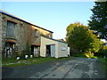
Old farm buildings at Tregays
Looking north-west towards Lostwithiel.
Image: © Jonathan Billinger
Taken: 8 Oct 2008
0.04 miles
2
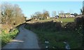
Tregays
A farming hamlet at the end of a no through road.
Image: © Derek Harper
Taken: 31 Mar 2016
0.06 miles
4
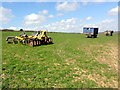
Farm Equipment in a Field
Arranged rather artistically I thought!
Image: © Tony Atkin
Taken: 20 Apr 2013
0.23 miles