IMAGES TAKEN NEAR TO
LOSTWITHIEL, PL22 0JJ
Introduction
This page details the photographs taken nearby to PL22 0JJ by members of the Geograph project.
The Geograph project started in 2005 with the aim of publishing, organising and preserving representative images for every square kilometre of Great Britain, Ireland and the Isle of Man.

There are currently over 7.5m images from over14,400 individuals and you can help contribute to the project by visiting https://www.geograph.org.uk
Image Map
Images are licensed for reuse under creativecommons.org/licenses/by-sa/2.0
Notes
- Clicking on the map will re-center to the selected point.
- The higher the marker number, the further away the image location is from the centre of the postcode.
Image Listing (18 Images Found)
Images are licensed for reuse under creativecommons.org/licenses/by-sa/2.0
Image
Details
Distance
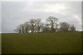
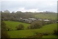
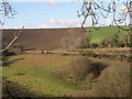
4
Perrose
Looking over the valley to a farmhouse called Perrose.
Image: © Tony Atkin
Taken: 21 Jan 2006
0.03 miles
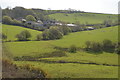
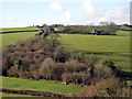
6

Above Treverran Tunnel
Clear view of the countryside and woods around Treverran Tunnel from the Fowey Road. The main Paddington to Penzance railway is seen then tunnels under the field and road below on its way to Par.
Image: © roger geach
Taken: 8 Oct 2009
0.13 miles
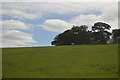
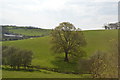
8
Across Milltown Valley
Looking westwards across the valley near the hamlet of Milltown. The main railway line through Cornwall can be seen running along the valley just in front of the pylon.
Image: © Tony Atkin
Taken: 21 Jan 2006
0.17 miles