IMAGES TAKEN NEAR TO
LOSTWITHIEL, PL22 0JH
Introduction
This page details the photographs taken nearby to PL22 0JH by members of the Geograph project.
The Geograph project started in 2005 with the aim of publishing, organising and preserving representative images for every square kilometre of Great Britain, Ireland and the Isle of Man.

There are currently over 7.5m images from over14,400 individuals and you can help contribute to the project by visiting https://www.geograph.org.uk
Image Map
Images are licensed for reuse under creativecommons.org/licenses/by-sa/2.0
Notes
- Clicking on the map will re-center to the selected point.
- The higher the marker number, the further away the image location is from the centre of the postcode.
Image Listing (4 Images Found)
Images are licensed for reuse under creativecommons.org/licenses/by-sa/2.0
Image
Details
Distance
3
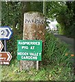
Old Guide Stone by the B3269, Pelyndowns, Lanlivery Parish
By the B3269, in parish of Lanlivery (Restormel District), Pelyndowns, junction beside "Treesmill 1/4" sign, by Hidden Farm Gardens, directions seem reversed.
Inscription reads:-
: PAR : : FOWEY :
Grade II listed. List Entry Number: 1327304
https://historicengland.org.uk/listing/the-list/list-entry/1327304
Surveyed
Milestone Society National ID: CW_XLLIV2
Image: © Milestone Society
Taken: Unknown
0.14 miles
4
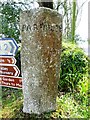
Old Guide Stone by the B3269, Pelyndowns
Guide Stone by the B3269, in parish of Lanlivery (Restormel District), Pelyndowns, junction beside "Treesmill 1/4" sign, by Hidden Farm Gardens, directions seem reversed.
Inscription reads:-
: PAR : : FOWEY :
Grade II listed.
List Entry Number: 1327304 https://historicengland.org.uk/listing/the-list/list-entry/1327304
Surveyed
Milestone Society National ID: CW_XLLIV2
Image: © Rosy Hanns
Taken: 5 Apr 2019
0.14 miles