IMAGES TAKEN NEAR TO
West Taphouse, LOSTWITHIEL, PL22 0FE
Introduction
This page details the photographs taken nearby to PL22 0FE by members of the Geograph project.
The Geograph project started in 2005 with the aim of publishing, organising and preserving representative images for every square kilometre of Great Britain, Ireland and the Isle of Man.

There are currently over 7.5m images from over14,400 individuals and you can help contribute to the project by visiting https://www.geograph.org.uk
Image Map
Images are licensed for reuse under creativecommons.org/licenses/by-sa/2.0
Notes
- Clicking on the map will re-center to the selected point.
- The higher the marker number, the further away the image location is from the centre of the postcode.
Image Listing (15 Images Found)
Images are licensed for reuse under creativecommons.org/licenses/by-sa/2.0
Image
Details
Distance
1
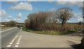
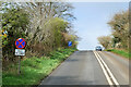
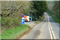
A390 near West Taphouse
A junction with two lanes leaving on the right; the one you can see leads to Penwater.
Image: © Derek Harper
Taken: 31 Mar 2016
0.02 miles
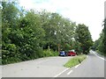
3
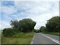
Field by the A390
Looking right from the same spot as Image The lane to Bagstone runs on the left.
Image: © Derek Harper
Taken: 31 Mar 2016
0.08 miles
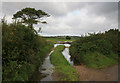
5
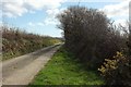
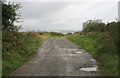
Lane to Bagstone
Running straight for over 700 metres from the junction shown in Image]
Image: © Derek Harper
Taken: 31 Mar 2016
0.11 miles
6
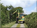
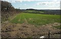
Hedge trimming
A job to do in the lull before harvesting.
Image: © Jonathan Billinger
Taken: 11 Jul 2007
0.11 miles
9
Plenty of water after gales
Field gateway full of water after storms
Image: © roger geach
Taken: 5 Sep 2011
0.16 miles