IMAGES TAKEN NEAR TO
St. Levan Road, PLYMOUTH, PL2 1JP
Introduction
This page details the photographs taken nearby to St. Levan Road, PL2 1JP by members of the Geograph project.
The Geograph project started in 2005 with the aim of publishing, organising and preserving representative images for every square kilometre of Great Britain, Ireland and the Isle of Man.

There are currently over 7.5m images from over14,400 individuals and you can help contribute to the project by visiting https://www.geograph.org.uk
Image Map
Images are licensed for reuse under creativecommons.org/licenses/by-sa/2.0
Notes
- Clicking on the map will re-center to the selected point.
- The higher the marker number, the further away the image location is from the centre of the postcode.
Image Listing (148 Images Found)
Images are licensed for reuse under creativecommons.org/licenses/by-sa/2.0
Image
Details
Distance
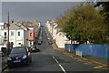
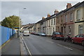
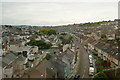
3
St Levan Road, Devonport
Viewed from a train on the railway viaduct.
Image: © Stephen Craven
Taken: 5 Aug 2018
0.01 miles
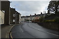
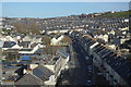
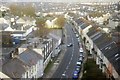
8
St Levan Road
Some of the hundreds of streets and houses in Keyham and Devonport serving the dockyard.
Image: © Graham Horn
Taken: 9 Jul 2011
0.03 miles
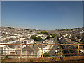
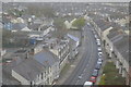
9
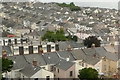
Rooftops of Keyham
Some of the many houses in the dockyard area of Plymouth.
This photo was taken from the 1158 Penzance to London Paddington train, having left Liskeard at 1332 and shortly to arrive at Plymouth.
Image: © Graham Horn
Taken: 9 Jul 2011
0.03 miles