IMAGES TAKEN NEAR TO
St. Vincent Street, PLYMOUTH, PL2 1JH
Introduction
This page details the photographs taken nearby to St. Vincent Street, PL2 1JH by members of the Geograph project.
The Geograph project started in 2005 with the aim of publishing, organising and preserving representative images for every square kilometre of Great Britain, Ireland and the Isle of Man.

There are currently over 7.5m images from over14,400 individuals and you can help contribute to the project by visiting https://www.geograph.org.uk
Image Map
Images are licensed for reuse under creativecommons.org/licenses/by-sa/2.0
Notes
- Clicking on the map will re-center to the selected point.
- The higher the marker number, the further away the image location is from the centre of the postcode.
Image Listing (147 Images Found)
Images are licensed for reuse under creativecommons.org/licenses/by-sa/2.0
Image
Details
Distance
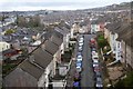
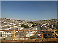
4
The old Ford Viaduct, Plymouth
This Viaduct was demolished in 1987.
I took the picture just weeks before it went - and once it had gone I really missed it in the urban landscape.
Image: © Ruth Sharville
Taken: Unknown
0.03 miles
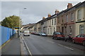
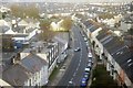
10
St Levan Road, Devonport
Viewed from a train on the railway viaduct.
Image: © Stephen Craven
Taken: 5 Aug 2018
0.04 miles