IMAGES TAKEN NEAR TO
Northesk Street, PLYMOUTH, PL2 1EY
Introduction
This page details the photographs taken nearby to Northesk Street, PL2 1EY by members of the Geograph project.
The Geograph project started in 2005 with the aim of publishing, organising and preserving representative images for every square kilometre of Great Britain, Ireland and the Isle of Man.

There are currently over 7.5m images from over14,400 individuals and you can help contribute to the project by visiting https://www.geograph.org.uk
Image Map
Images are licensed for reuse under creativecommons.org/licenses/by-sa/2.0
Notes
- Clicking on the map will re-center to the selected point.
- The higher the marker number, the further away the image location is from the centre of the postcode.
Image Listing (149 Images Found)
Images are licensed for reuse under creativecommons.org/licenses/by-sa/2.0
Image
Details
Distance
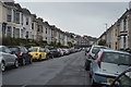
2
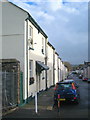
Terraced housing in Packington Street
Typical of much of the area surrounding Mount Pleasant.
Image: © Rod Allday
Taken: 17 Nov 2010
0.04 miles
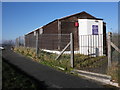
4
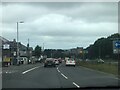
Gloomy A386
A386 on a gloomy Tuesday morning
Image: © Noah Drury
Taken: 17 Aug 2021
0.05 miles
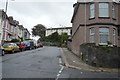
6
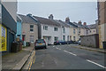
Plymouth : Bromley Place
Looking along Bromley Place off Devonport Road.
Image: © Lewis Clarke
Taken: 17 Mar 2020
0.07 miles
7
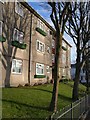
Flats, Packington Street
These flats are at the east end of Packington Street, near the junction with Ford Hill.
Image: © Derek Harper
Taken: 9 Feb 2010
0.07 miles
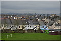
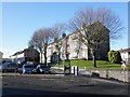
8
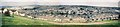
Plymouth: endless grey rooftops
A panorama north from Mount Pleasant Redoubt viewpoint.
Image: © Chris Downer
Taken: 7 Aug 1996
0.07 miles