IMAGES TAKEN NEAR TO
Sanctuary Close, PLYMOUTH, PL2 1EN
Introduction
This page details the photographs taken nearby to Sanctuary Close, PL2 1EN by members of the Geograph project.
The Geograph project started in 2005 with the aim of publishing, organising and preserving representative images for every square kilometre of Great Britain, Ireland and the Isle of Man.

There are currently over 7.5m images from over14,400 individuals and you can help contribute to the project by visiting https://www.geograph.org.uk
Image Map (Loading...)


Getting Data...Please wait
Leaflet Map data © OpenStreetMap
Images are licensed for reuse under creativecommons.org/licenses/by-sa/2.0
Notes
- Clicking on the map will re-center to the selected point.
- The higher the marker number, the further away the image location is from the centre of the postcode.
Image Listing (76 Images Found)
Images are licensed for reuse under creativecommons.org/licenses/by-sa/2.0
Image
Details
Distance
7
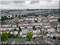
Ford Valley
Looking down from the high viewpoint of The Blockhouse near Stoke Village into the steep Ford Valley full of late 19th Century houses. The line of trees crossing the picture about two thirds of the way up marks the location of the old Southern Railway line which is now parkland.
Image: © Tony Atkin
Taken: 29 Jul 2005
0.07 miles