IMAGES TAKEN NEAR TO
Orchard Court, IVYBRIDGE, PL21 9UB
Introduction
This page details the photographs taken nearby to Orchard Court, PL21 9UB by members of the Geograph project.
The Geograph project started in 2005 with the aim of publishing, organising and preserving representative images for every square kilometre of Great Britain, Ireland and the Isle of Man.

There are currently over 7.5m images from over14,400 individuals and you can help contribute to the project by visiting https://www.geograph.org.uk
Image Map
Images are licensed for reuse under creativecommons.org/licenses/by-sa/2.0
Notes
- Clicking on the map will re-center to the selected point.
- The higher the marker number, the further away the image location is from the centre of the postcode.
Image Listing (25 Images Found)
Images are licensed for reuse under creativecommons.org/licenses/by-sa/2.0
Image
Details
Distance
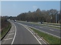
1
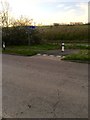
Start of a Cycle Track
Heading towards Lee Mill .
Image: © jeff collins
Taken: 5 Apr 2020
0.07 miles
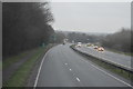
3
The A38 eastbound at the B3213 Ivybridge slip road
Image: © Ian S
Taken: 26 May 2013
0.07 miles
4
A38 Duel Carriage Way
Heading East towards Exeter.
Image: © jeff collins
Taken: 5 Apr 2020
0.07 miles
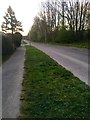
5

Road Junction
The junction of Fairway Avenue with Woodland Road.
Image: © jeff collins
Taken: 31 May 2020
0.08 miles
7
Lower end of Cornwood Road
Looking East towards Ivybridge.
Image: © jeff collins
Taken: 5 Apr 2020
0.10 miles

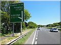
9
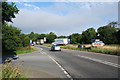
Slip road
The entry slip road onto the A38 at Ivybridge.
Image: © jeff collins
Taken: 4 Sep 2013
0.10 miles
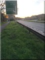
10
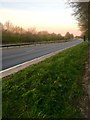
A38 Dual Carriageway
Looking in the direction of Plymouth.
Image: © jeff collins
Taken: 5 Apr 2020
0.11 miles