IMAGES TAKEN NEAR TO
Ermington, IVYBRIDGE, PL21 9NU
Introduction
This page details the photographs taken nearby to PL21 9NU by members of the Geograph project.
The Geograph project started in 2005 with the aim of publishing, organising and preserving representative images for every square kilometre of Great Britain, Ireland and the Isle of Man.

There are currently over 7.5m images from over14,400 individuals and you can help contribute to the project by visiting https://www.geograph.org.uk
Image Map
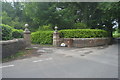
Images are licensed for reuse under creativecommons.org/licenses/by-sa/2.0
Notes
- Clicking on the map will re-center to the selected point.
- The higher the marker number, the further away the image location is from the centre of the postcode.
Image Listing (25 Images Found)
Images are licensed for reuse under creativecommons.org/licenses/by-sa/2.0
Image
Details
Distance
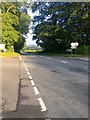
2
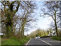
Primroses and ivy-covered trees, Flete Wood
Approaching the junction of A379 with the road to Holbeton
Image: © David Smith
Taken: 16 Apr 2015
0.02 miles
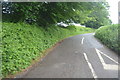
7
Lane off the A379
Close to Western Lodge.
Image: © jeff collins
Taken: 1 Aug 2020
0.05 miles
8
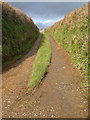
Track near Waye Farm
Grass up the centre of this short stretch of track which formerly linked through to Burraton. Seen from the lane between Waye Farm and Clickland.
Image: © Derek Harper
Taken: 26 Nov 2006
0.12 miles
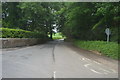
9
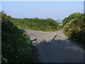
Nearing the A379
Nearing the A379, the right turn takes you down past Waye Farm
Image: © Shaun Ferguson
Taken: 15 Aug 2010
0.12 miles
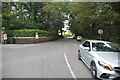
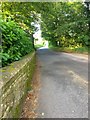
10
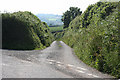
Ermington: lane to Waye Farm
The housing near the skyline is Yeo Park, Yealmpton
Image: © Martin Bodman
Taken: 11 Jun 2010
0.13 miles